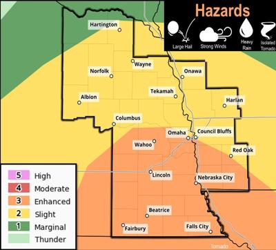

(KMAland) -- Most of southwest Iowa, southeast Nebraska and northwest Missouri remain in an enhanced risk for severe weather late Tuesday and early Wednesday morning.
The Storm Prediction Center says the most likely timing puts severe weather in the Omaha and Lincoln areas between 7-10 p.m. and then into southwest Iowa, southeast Nebraska and northwest Missouri later in the evening. Weatherology Forecaster Cara Foster says the storms could include a number of severe events.
"The main threats will be some heavy rainfall and some large hail," said Foster. "There is a small chance for some tornadic activity, but it is a little bit further south. It will mainly be the winds, heavy rain and some hail. Once again, that is overnight tonight."
Areas of western Iowa north and east of a line between Council Bluffs and Red Oak remain in a slight risk for severe weather this evening. Stay tuned to KMA Radio and kmaland.com for the latest severe weather coverage.