Skip to content
NOWCAST WDSU News at 4:30am
Live Now
Advertisement

A warmer, drier winter expected

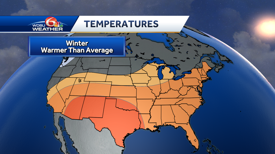
la nina usually means warmer than normal winters
WDSU
la nina usually means warmer than normal winters
SOURCE: WDSU
Advertisement
A warmer, drier winter expected
Local temperatures have been warmer than normal recently, and it appears that will be a trend through the winter months. For the second year in a row, a La Nina has developed. The tropical east Pacific waters are cooler than average, signaling another La Nina winter. La Nina impacts the weather across the world, including right here at home. When the water in the central and eastern Pacific is cooler, it influences the Pacific jet stream and keeps it further north.When the jet stream stays north, more storms roll across northern portions of the country, leaving the southern states drier than normal.During a La Nina year, it also stays warmer than average in the southern states during the winter months.The maps above show the Climate Prediction Centers outlook for the next three months, forecasting a warmer and drier pattern here at home.Besides La Nina, there are also El Nino and Neutral years. El Nino is essentially the opposite of La Nina, with warmer waters in the tropical Pacific and a cooler and wetter winter here at home. The strongest El Nino on record was the 1997-1998 El Nino. Comparably, January 1998 was the rainiest on record in New Orleans. A total of 19.28 inches of rain fell that month.El Nino and La Nina also impact our weather in other ways, including hurricane frequency. During a La Nina year, hurricane season is usually more active. Likewise, we've had extremely active seasons the past two years.

Local temperatures have been warmer than normal recently, and it appears that will be a trend through the winter months. For the second year in a row, a La Nina has developed.

The tropical east Pacific waters are cooler than average, signaling another La Nina winter. La Nina impacts the weather across the world, including right here at home. When the water in the central and eastern Pacific is cooler, it influences the Pacific jet stream and keeps it further north.

Advertisement
la nina has formed due to cooler than normal waters in the tropical pacific
Hearst OwnedWDSU

When the jet stream stays north, more storms roll across northern portions of the country, leaving the southern states drier than normal.

la nina usually means drier than normal winters
Hearst OwnedWDSU

During a La Nina year, it also stays warmer than average in the southern states during the winter months.

la nina usually means warmer than normal winters
Hearst OwnedWDSU

The maps above show the Climate Prediction Centers outlook for the next three months, forecasting a warmer and drier pattern here at home.

Besides La Nina, there are also El Nino and Neutral years. El Nino is essentially the opposite of La Nina, with warmer waters in the tropical Pacific and a cooler and wetter winter here at home.

The strongest El Nino on record was the 1997-1998 El Nino. Comparably, January 1998 was the rainiest on record in New Orleans. A total of 19.28 inches of rain fell that month.

El Nino and La Nina also impact our weather in other ways, including hurricane frequency. During a La Nina year, hurricane season is usually more active. Likewise, we've had extremely active seasons the past two years.