

It's time to reimagine visitor use at Hunting Island State Park. Long-term sea level rise is dramatically changing this park, but not in the way that most people would imagine.
Hunting Island is a low-elevation barrier island with a dense, beautiful maritime forest covering ancient dunes throughout most of the island. The backside has a wide Spartina salt marsh typical of so much of the Lowcountry. According to the U.S. Geological Survey, Hunting Island also has one of the highest erosion rates on the East Coast. It has been this way for a while.
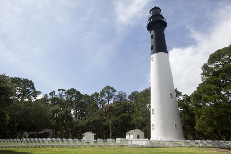
The historic Hunting Island Lighthouse was constructed to be moved. In 1889, the lighthouse was moved 1.3 miles inland. It now stands a few hundred feet from the beach. The view from the top is fabulous, but the builders never intended to protect that lighthouse in place.
The state of South Carolina, however, has spent millions of dollars trying to hold the beach in place by pumping sand and building sheet-pile and rock groins. Why would we spend so much money putting rocks on a “protected” beach inside a state park? The 5,000-acre park is the most visited in the South Carolina State Park system, providing substantial annual revenue.
I have been coming to Hunting Island since I was a boy in the late 1960s. Check out some of the groups dedicated to the park on social media, and you will gain an appreciation for how many people love this place.
But that love cannot save Hunting Island from the inevitable changes being brought by a changing climate and rising sea level. The greatest threat to future visitor use of Hunting Island is not shoreline change. It's constant flooding and standing water.
Rising sea level doesn’t just move beaches; it also lifts the local water table. In other words, the water is rising beneath Hunting Island. When the water table is literally at, or inches below, the surface, precipitation will flood the island. The rain has nowhere else to go. In the Lowcountry’s humid climate, that water will not evaporate quickly, and it cannot go into the ground.
Additionally, king tides raise the groundwater just as they cause unusually high tides in general. The lowest spots on the island can flood because the water table intersects the ground level.
All of this flooding is causing a die-off of vegetation in some areas. Losing trees makes the situation even worse because the trees help pump water out of the ground and into the sky.
I’m afraid all this presents a future where Hunting Island will be more wet than dry. The island will lose maritime forest and gain wetlands. The park will struggle to maintain the same level of visitor access because the flooding will become more frequent.
Recently, S.C. Parks, Recreation and Tourism applied for a permit to tear down a section of newly constructed sand dune in an attempt to drain some of the persistent flood water. It will not be the last time.
What we really need is a new vision for how visitors will be able to experience the island, and a long-term management plan that examines all of the coming challenges. It needs to account for the costs that will be incurred by trying to maintain the high visitor usage of the past few decades. Visitor revenues may be high, but the costs of maintaining access are increasing rapidly.
This does not mean the end to Hunting Island. The island itself will be different, but fine.
Those of us who love the place may have to be willing to change the relationship we have with the park. We need to preserve the place, and not the parking. And PRT will need to imagine a future managing a different kind of visitor experience. I’m sure all of us who love Hunting Island State Park will be happy to help guide that plan.
Rob Young is a member of the S.C. Floodwater Commission and director of the Program for the Study of Developed Shorelines at Western Carolina University.


