
The Climate Prediction Center’s new outlooks for the remainder of winter and the coming spring indicate warmer than normal and drier than normal conditions are likely to prevail over Texas. These are the outlooks for temperature and precipitation for the February-March-April timeframe.


Below, the outlooks for our coming spring indicate drier and warmer than normal weather across all of Texas during the three month period March-April-May, or meteorological spring.


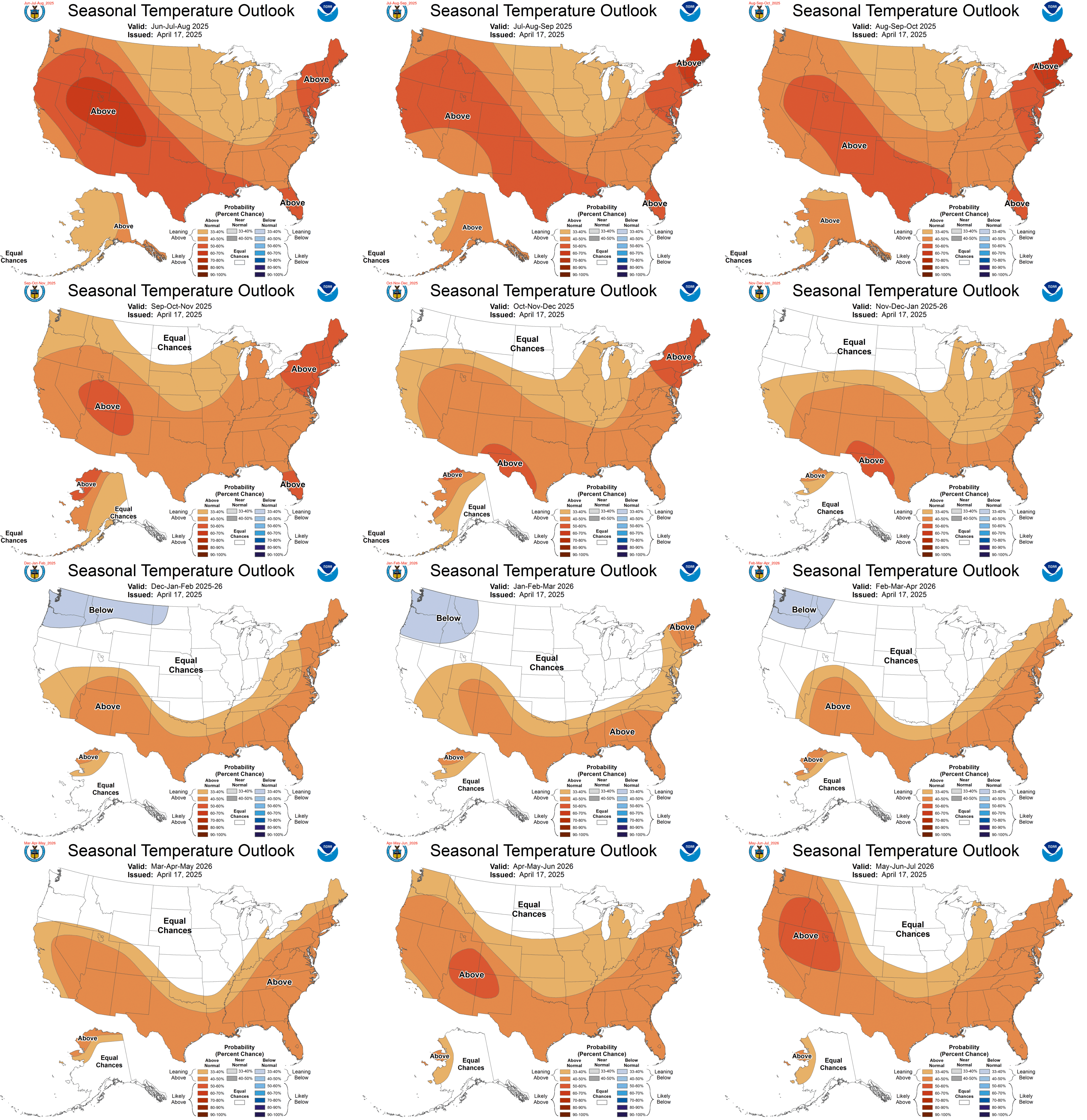
Here are all the outlooks into 2022. The continued impacts of global warming have warmer than normal temperatures predicted during every three month period.
The precipitation outlooks into 2022 indicate equal chances for wetter or drier than normal weather in Texas after this spring.

Here is the CPC’s discussion related to this month’s outlooks:
SUMMARY OF THE OUTLOOK FOR NON-TECHNICAL USERS
La Nina conditions are present across the equatorial Pacific Ocean, as
indicated by current oceanic and atmospheric observations. La Nina is expected
to continue through the Northern Hemisphere winter (~95% chance), with a
potential transition to ENSO-neutral (~55% chance) during April-May-June 2021.
The February-March-April (FMA) temperature outlook favors below normal seasonal
mean temperatures for the southern half of mainland Alaska, the Alaska
Panhandle, and from the Pacific Northwest eastward to the Northern Rockies.
Above normal seasonal mean temperatures are favored across parts of northern
and western Alaska, and for most of the CONUS, except portions of the Northern
Plains, Northern Rockies, Southern Oregon, and Northern California. Maximum
probabilities for above normal temperatures exceed 60% across parts of the
Southwest and Southern Great Plains. The FMA precipitation outlook favors above
normal precipitation for most of the northern tier of the CONUS, extending from
the Pacific Northwest to the Great Lakes, then southward across eastern
portions of the Middle Mississippi Valley, the Ohio Valley, and the Central and
Northern Appalachians. Above normal precipitation is also favored for northern
and western portions of Alaska. Maximum probabilities for above normal
precipitation exceed 50% over the Ohio Valley. From central and southern
California across the Great Basin to the Central and Southern Plains, below
normal precipitation is favored. Below normal precipitation is the most favored
outcome across portions of the Southeast, as well as along the southern coast
of mainland Alaska and for the Alaska Panhandle.
Equal Chances (EC) are forecast for areas where probabilities for each category
of seasonal mean temperatures or seasonal total precipitation amounts are
predicted to be similar to climatological probabilities.
BASIS AND SUMMARY OF THE CURRENT LONG-LEAD OUTLOOKS
CURRENT ATMOSPHERIC AND OCEANIC CONDITIONS
Tropical oceanic and atmospheric observations reflect ongoing La Nina
conditions. During the past 30-days, an area of negative sea-surface
temperature (SST) anomalies was located from about 160 deg E to the coast of
South America. SST anomalies for the period ranged between 0.5 deg C to 1.5 deg
C over most of this region, with the strongest anomalies from 170-150 deg W.
Some warming has occurred recently, east of 135W. Subsurface temperatures were
colder-than-average for the same region, down to a depth of about 175 meters.
The Oceanic Nino 3.4 Index (ONI) for the latest observed season (OND 2020) is
-1.3 deg C, which qualifies as a moderate La Nina at this time. Atmospheric
observations reflect enhanced easterly trade winds at 850-hPa from the western
to the east-central equatorial Pacific, westerly wind anomalies at 200-hPa over
most of the Pacific, and suppressed tropical convection over the western and
central Pacific. The atmospheric conditions reflect a canonical La Nina
response.
PROGNOSTIC DISCUSSION OF SST FORECASTS
The CPC Nino3.4 SST consolidation depicts negative SST anomalies weakening (so
warming) through the remainder of the winter and spring of 2021. The
consolidation forecast predicts the ONI value will cross the -0.5 deg C
threshold into ENSO-neutral territory during FMA 2021, and reach the zero
anomaly line by AMJ 2021. This is slightly warmer than last month’s SST CON.
The NMME ensemble mean SST plume for the Nino 3.4 region reaches the -0.5 deg C
threshold by April 2021, and continues to warm slightly through summer 2021.
The C3S (Copernicus) SST plume reaches the ENSO-neutral threshold slightly
earlier, in Feb, then remains at or about -0.5 deg C until June. The CPC-IRI
consensus predicts the likelihood of La Nina will drop to the same likelihood
of ENSO-neutral by about AMJ 2021. The official ENSO forecast calls for
approximately a 95% chance for La Nina to continue through Northern Hemisphere
winter, with a potential transition during the spring 2021 (~55% chance of ENSO
Neutral during AMJ 2021).
PROGNOSTIC TOOLS USED FOR U.S. TEMPERATURE AND PRECIPITATION OUTLOOKS
Given a very high likelihood of the persistence of La Nina conditions, the
seasonal outlooks utilized canonical impacts during past observed La Nina
events as guidance for many areas of the forecast domain through at least MAM
- This guidance included regressions of temperature and precipitation
relative to the CPC consolidation forecasts of the Nino3.4 region and via
“bridging” techniques utilizing statistical relationships between dynamical
model forecasts of the Nino 3.4 index and observed temperature and
precipitation. Dynamical model guidance from the North American Multi-Model
Ensemble (NMME) and the model suite from the Copernicus program are a
significant component of guidance for the temperature and precipitation
outlooks through JJA 2021. Beyond JJA 2021, the consolidation of various
statistical tools, including decadal trends , was the primary basis for the
outlooks, with little remaining influence from ENSO or other reliable
large-scale signals of climate variability for these forecast leads. Predicted
low soil moisture conditions as a result of predicted precipitation totals over
already dry areas, influenced the temperature outlooks for the spring and early
summer 2021 over the Central Plains and Southwest. At later leads, decadal
trends in temperature and precipitation were the primary tool used in creating
the seasonal outlooks.
PROGNOSTIC DISCUSSION OF OUTLOOKS – FMA 2021 TO FMA 2022
TEMPERATURE
The temperature outlook for FMA 2021 reflects current model guidance, blended
with likely impacts of La Nina and trends . The favoring of below normal
temperatures across portions of mainland Alaska, the Alaska Panhandle, and the
Pacific Northwest reflect La Nina conditions. The outlook is slightly warmer
than last month’s outlook but colder than the recent model guidance for this
region. The FMA outlook for the Northern Great Plains is warmer than last
month’s lead 2 outlook, reflecting the ongoing lack of snow cover and more
recent model guidance, though probabilities are modest at best from North
Dakota to Illinois. Odds for above normal temperatures were also increased
across the Lower Mississippi, Gulf Coast, and Florida, reflecting recent model
guidance and likely La Nina impacts. The outlooks for later spring and summer
2021 reflect recent model guidance and trends , with the lowest probabilities in
the central portions of the CONUS where variances are highest, model skill
lowest, and trends are small to negative. Outlooks for next autumn were
unchanged, as the reasoning behind the outlooks has not changed for those
periods, and trends are the most reliable tool. Some outlooks are calling for
a second La Nina winter, which would not be unprecedented since 1950, and the
outlooks for next winter are already aligned for that possibility.
PRECIPITATION
La Nina is the primary physical driver behind the subsequent FMA and MAM
precipitation outlooks, so only minor adjustments were needed to the
corresponding outlooks made last month. In MAM, the amplitude of La Nina and
its associated precipitation impacts are expected to begin to decline. In AMJ
2021, below normal precipitation amounts are forecast to diminish in spatial
coverage across the southern CONUS, and be centered over most of the
southwestern quarter of the CONUS. After AMJ, with a predicted ENSO Neutral,
trends are more highly factored, which favors below normal precipitation for
portions of the Northern and Central Rockies during summer months, shifting
southward during the winter. East of the Mississippi, summer and early autumn
months have a wet trend. By next winter, Dec-Jan-Feb 2021-22, the only
remaining signal is the trend for above normal precipitation over the Northern
Plains.


